
Guidebook for Maggie Valley. Francisco's Main House and Guest Tower
Sightseeing
Great fun and attraction during the Winter. Only 14 minutes from the property. To get to the ski area, come through the town of Maggie Valley turn onto Fie Top Road (at Ghost Town in the Sky and across from Tube World) and continue up that road for 3 miles and then 1 mile across on Ski Lodge Road to the ski area. Do not turn off of Fie Top Road onto any other road other than Ski Lodge Road. Also, Tube World is located at the base of the mountain in the town of Maggie Valley and not at the ski area. They are situated on Soco Road across from Ghost Town.
231 명의 현지인이 추천하는 곳
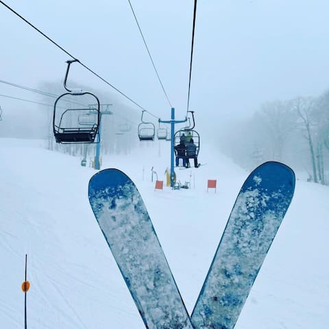
캐털루치 스키장
1080 Ski Lodge RdGreat fun and attraction during the Winter. Only 14 minutes from the property. To get to the ski area, come through the town of Maggie Valley turn onto Fie Top Road (at Ghost Town in the Sky and across from Tube World) and continue up that road for 3 miles and then 1 mile across on Ski Lodge Road to the ski area. Do not turn off of Fie Top Road onto any other road other than Ski Lodge Road. Also, Tube World is located at the base of the mountain in the town of Maggie Valley and not at the ski area. They are situated on Soco Road across from Ghost Town.
Waynesville is only 7 miles from the property. Its main street depicts the charm and hospitality of our small Southern communities. It has many antique shops, arts and crafts shoos, art galleries, restaurants, coffee shops, ice cream parlors, small general stores and much more.
184 명의 현지인이 추천하는 곳
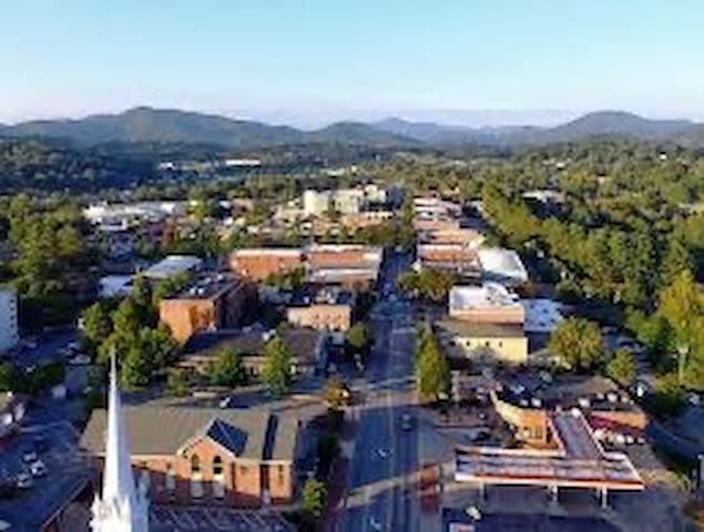
Waynesville
Waynesville is only 7 miles from the property. Its main street depicts the charm and hospitality of our small Southern communities. It has many antique shops, arts and crafts shoos, art galleries, restaurants, coffee shops, ice cream parlors, small general stores and much more.
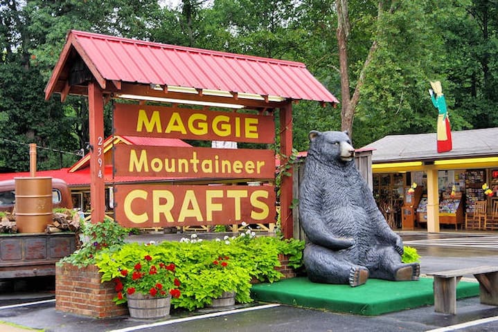
Maggie Valley is a quaint small town located on the border with the Great Smoky Mountains National Park and two national forests. It offers many outdoor pursuits like hiking, camping, biking, whitewater rafting and horseback riding are favorites. You can also head over to the Cataloochee Valley area of the park and see the elk, which has been successfully reintroduced into the park. Activities in the Valley include miniature golf, golf at the Maggie Valley Club, summer and winter tubing, fishing in our Heritage Trout Waters, antiquing, museums, skiing, snowboarding, tubing and more. Don’t miss the latest attraction, the Elevated Mountain Distilling Company.
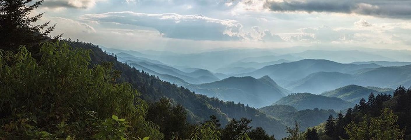
The Great Smoky Mountains National Park is one of the most unspoiled ecosystems in the country. The park is largely inaccessible by car except for a few roads that go around the park and by hwy 441 which runs from Cherokee and Gatlinburg. To see the best parts of the park you'll need to put on your hiking shoes and start walking. Trekking off the beaten path will be rewarded with solitude and some amazing sites. For example, a small barely marked trail from the Clingman's Dome parking area leads to Andrews Bald. The 1.5 mile hike is moderate and at the end, the hikers is rewarded some of the best-unobstructed views of the park. Winter hikes are also rewarding with the lack of traffic on the trails and with the leaves down the views are everywhere. For detailed and updated information about attractions, festivals, seasonal activities and much more, please visit the MaggieValley Chamber of Commerce Web Page at https://www.maggievalley.org/
Trout Fishing
Maggie Valley and Jonathan Creek is a state-designated Heritage Trout Waters area. Maggie Valley is designated as one of five Mountain Heritage Trout Cities in this pilot program in NC.
The NC Wildlife Resources Commission, which sells the Mountain Heritage Trout Waters license, gives anglers two quick and easy ways to purchase a license: on-line: www.ncwildlife.org or by phone: 888-248-6834. The license is valid for a 3-day period and costs: $5 for residents and non-residents age 16 and older. The license is valid only for waters that are designated as Mountain Heritage Trout Waters.
108 명의 현지인이 추천하는 곳
Maggie Valley
Maggie Valley is a quaint small town located on the border with the Great Smoky Mountains National Park and two national forests. It offers many outdoor pursuits like hiking, camping, biking, whitewater rafting and horseback riding are favorites. You can also head over to the Cataloochee Valley area of the park and see the elk, which has been successfully reintroduced into the park. Activities in the Valley include miniature golf, golf at the Maggie Valley Club, summer and winter tubing, fishing in our Heritage Trout Waters, antiquing, museums, skiing, snowboarding, tubing and more. Don’t miss the latest attraction, the Elevated Mountain Distilling Company.
The Great Smoky Mountains National Park is one of the most unspoiled ecosystems in the country. The park is largely inaccessible by car except for a few roads that go around the park and by hwy 441 which runs from Cherokee and Gatlinburg. To see the best parts of the park you'll need to put on your hiking shoes and start walking. Trekking off the beaten path will be rewarded with solitude and some amazing sites. For example, a small barely marked trail from the Clingman's Dome parking area leads to Andrews Bald. The 1.5 mile hike is moderate and at the end, the hikers is rewarded some of the best-unobstructed views of the park. Winter hikes are also rewarding with the lack of traffic on the trails and with the leaves down the views are everywhere. For detailed and updated information about attractions, festivals, seasonal activities and much more, please visit the MaggieValley Chamber of Commerce Web Page at https://www.maggievalley.org/
Trout Fishing
Maggie Valley and Jonathan Creek is a state-designated Heritage Trout Waters area. Maggie Valley is designated as one of five Mountain Heritage Trout Cities in this pilot program in NC.
The NC Wildlife Resources Commission, which sells the Mountain Heritage Trout Waters license, gives anglers two quick and easy ways to purchase a license: on-line: www.ncwildlife.org or by phone: 888-248-6834. The license is valid for a 3-day period and costs: $5 for residents and non-residents age 16 and older. The license is valid only for waters that are designated as Mountain Heritage Trout Waters.
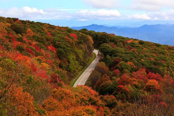
Soco Falls
U.S. Highway 19The Blue Ridge Parkway's exit at Soco Gap is the most frequently used access to the scenic road. from here you can go south to the southern end of the road in Cherokee and turn right to visit the mountain farmstead museum at the entrance to the park, or turn left and enter the Cherokee Indian reservation. If you head north, the whole length of the parkway is in front of you. a short drive will take you to a hikers favorite, Waterrock knob. From the parking area great sunsets are a daily occurrence. farther north you will pass some great vistas and hiking locations like Graveyard Fields, Devils Courthouse and Mount Pisgah.
The Blue Ridge Parkway
The Blue Ridge Parkway is open to drive and enjoy the views. Most picnic areas, restrooms, campgrounds and visitor centers are open; however check before you go – Learn what’s open.
The Parkway begins in Swain County in Cherokee, at the entrance to the Great Smoky Mountains National Park. (milepost 469.1). The Parkway is a beautiful drive spring through fall (sometimes closed in winter due to weather), and you’ll have plenty of time to enjoy the ride and the views because the speed limit is generally 45 mph. (Remember to factor that in to your time expectations for these trips.) And please note, restrooms and dining spots on the Parkway are limited.
250 명의 현지인이 추천하는 곳
Blue Ridge Parkway
Blue Ridge ParkwayThe Blue Ridge Parkway's exit at Soco Gap is the most frequently used access to the scenic road. from here you can go south to the southern end of the road in Cherokee and turn right to visit the mountain farmstead museum at the entrance to the park, or turn left and enter the Cherokee Indian reservation. If you head north, the whole length of the parkway is in front of you. a short drive will take you to a hikers favorite, Waterrock knob. From the parking area great sunsets are a daily occurrence. farther north you will pass some great vistas and hiking locations like Graveyard Fields, Devils Courthouse and Mount Pisgah.
The Blue Ridge Parkway
The Blue Ridge Parkway is open to drive and enjoy the views. Most picnic areas, restrooms, campgrounds and visitor centers are open; however check before you go – Learn what’s open.
The Parkway begins in Swain County in Cherokee, at the entrance to the Great Smoky Mountains National Park. (milepost 469.1). The Parkway is a beautiful drive spring through fall (sometimes closed in winter due to weather), and you’ll have plenty of time to enjoy the ride and the views because the speed limit is generally 45 mph. (Remember to factor that in to your time expectations for these trips.) And please note, restrooms and dining spots on the Parkway are limited.
The Cherohala Skyway
The spectacular 51-mile skyway connects Hwy. 143 in Robbinsville, NC to Hwy.165 in Tellico Plains, TN, traveling through the Cherokee and Nantahala National Forests. The name comes from a combination of these two forests.
The road was opened in 1996 and is a National Scenic Byway with beautiful overlooks, hiking trails and a beautiful waterfall. The road is quite curvy so please maintain the 40 & 45 mph posted speed limits. Note, there are no restrooms, gas stations or places to eat on the Skyway.
27 명의 현지인이 추천하는 곳
Cherohala Skyway
Cherohala SkywayThe Cherohala Skyway
The spectacular 51-mile skyway connects Hwy. 143 in Robbinsville, NC to Hwy.165 in Tellico Plains, TN, traveling through the Cherokee and Nantahala National Forests. The name comes from a combination of these two forests.
The road was opened in 1996 and is a National Scenic Byway with beautiful overlooks, hiking trails and a beautiful waterfall. The road is quite curvy so please maintain the 40 & 45 mph posted speed limits. Note, there are no restrooms, gas stations or places to eat on the Skyway.
Two Enjoyable Drives on the Parkway…
MAGGIE VALLEY TO CHEROKEE TO BALSAM GAP
A nice short segment to drive would be the 26 miles from Cherokee to the Balsam Gap exit at milepost 443, just west of Waynesville, NC on US 74. (return to Bryson City on US 74).
Along the way, you’ll pass the Big Witch Overlook with a view of Cherokee Valley; and Waterrock Knob (milepost 451) where there is a visitor information center, comfort station and a spectacular view. Take the half-mile trail to the summit for an even better view. The nearly-360 degree vantage point is uniquely suited for viewing – and photographing – sunrises and sunsets.
BALSAM GAP TO MT. PISGAH
This 35-mile segment begins just west of Waynesville NC at the Balsam Gap entrance (milepost 443.1). There are several beautiful overlooks on this section including the Richland Balsam Overlook (milepost 431.4) which is the highest point on the Blue Ridge Parkway (6,047 ft.).
Another stop is Devil’s Courthouse. A strenuous half-mile hike to the “Courthouse” provides a 360-view. (milepost 422.4).
Graveyard Fields Overlook has a loop trail of moderate difficulty, 2.3 miles to Yellowstone Falls. There is a comfort station. Graveyard Fields is well known for blueberries. The peak at that elevation is mid-August; you are allowed 1 gallon per day for personal consumption.
Next stop – Looking Glass Rock (milepost 417), and the Pisgah Inn Restaurant (open April – October at milepost 408.6). The restaurant is always busy, with a possible hour wait at the peak of the fall season.
Return to Maggie Valley: Drive 22 miles north to Waynesville and return on US 74.
168 명의 현지인이 추천하는 곳
Bryson City
Two Enjoyable Drives on the Parkway…
MAGGIE VALLEY TO CHEROKEE TO BALSAM GAP
A nice short segment to drive would be the 26 miles from Cherokee to the Balsam Gap exit at milepost 443, just west of Waynesville, NC on US 74. (return to Bryson City on US 74).
Along the way, you’ll pass the Big Witch Overlook with a view of Cherokee Valley; and Waterrock Knob (milepost 451) where there is a visitor information center, comfort station and a spectacular view. Take the half-mile trail to the summit for an even better view. The nearly-360 degree vantage point is uniquely suited for viewing – and photographing – sunrises and sunsets.
BALSAM GAP TO MT. PISGAH
This 35-mile segment begins just west of Waynesville NC at the Balsam Gap entrance (milepost 443.1). There are several beautiful overlooks on this section including the Richland Balsam Overlook (milepost 431.4) which is the highest point on the Blue Ridge Parkway (6,047 ft.).
Another stop is Devil’s Courthouse. A strenuous half-mile hike to the “Courthouse” provides a 360-view. (milepost 422.4).
Graveyard Fields Overlook has a loop trail of moderate difficulty, 2.3 miles to Yellowstone Falls. There is a comfort station. Graveyard Fields is well known for blueberries. The peak at that elevation is mid-August; you are allowed 1 gallon per day for personal consumption.
Next stop – Looking Glass Rock (milepost 417), and the Pisgah Inn Restaurant (open April – October at milepost 408.6). The restaurant is always busy, with a possible hour wait at the peak of the fall season.
Return to Maggie Valley: Drive 22 miles north to Waynesville and return on US 74.
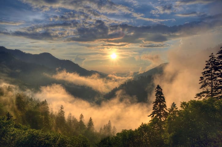
Spots for great Photos
Take This Mini Road Trip to Capture Some Great Photos
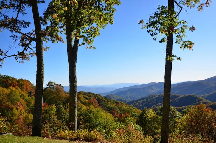
Whether you’re a professional photographer or an amateur, the Great Smoky Mountains National Park is one of the most diverse and photogenic landscapes in the United States. Verdant forests, long range mountain views, beautiful streams and serene valleys make this national treasure one of the richest experiences for landscape photography. Read along to find the best spots for sunrise and sunset photography on the North Carolina side, along with great photo opportunities along the way.
Our location descriptions are described via mileage distance from the Cherokee entrance to the Park (US 441/Newfound Gap Road), using the Great Smoky Mountains Entrance Sign as a starting point. You will find some mile markers along the way, however these are sometimes hard to find during snow events or tall summer grass.
67 명의 현지인이 추천하는 곳
오코날러프티 방문자 센터
1194 Newfound Gap RdTake This Mini Road Trip to Capture Some Great Photos
Whether you’re a professional photographer or an amateur, the Great Smoky Mountains National Park is one of the most diverse and photogenic landscapes in the United States. Verdant forests, long range mountain views, beautiful streams and serene valleys make this national treasure one of the richest experiences for landscape photography. Read along to find the best spots for sunrise and sunset photography on the North Carolina side, along with great photo opportunities along the way.
Our location descriptions are described via mileage distance from the Cherokee entrance to the Park (US 441/Newfound Gap Road), using the Great Smoky Mountains Entrance Sign as a starting point. You will find some mile markers along the way, however these are sometimes hard to find during snow events or tall summer grass.
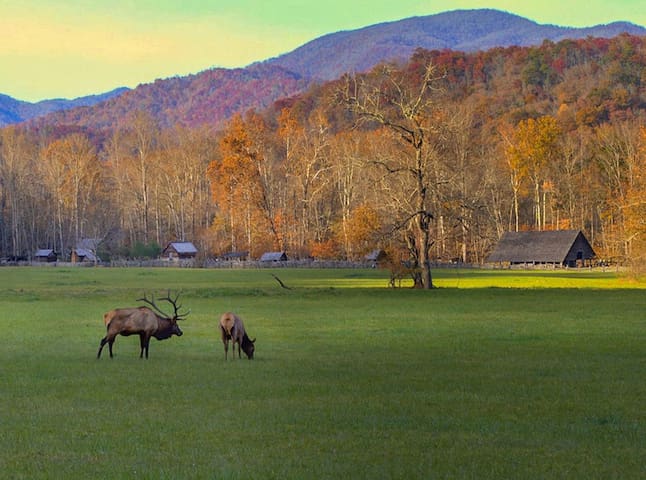
At 9/10ths of a mile, look to the right for the entrance to the Oconaluftee Visitor Center. This is the parking area for exploring the Mountain Farm Museum. There is a good chance you’ll see elk grazing in the field here during certain times of the day.
19 명의 현지인이 추천하는 곳
산악 농장 박물관
At 9/10ths of a mile, look to the right for the entrance to the Oconaluftee Visitor Center. This is the parking area for exploring the Mountain Farm Museum. There is a good chance you’ll see elk grazing in the field here during certain times of the day.
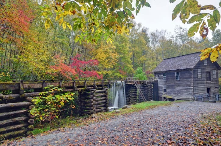
At 1.6 miles, look for the left turn into Mingus Mill. There are some great photo opportunities here. One of our favorites is to stand at the far end of the millrace – on the board that crosses over the millrace – looking toward the mill. This puts the millrace in the foreground of the photo with the mill in the background.
16 명의 현지인이 추천하는 곳
Mingus Mill
Mingus Creek TrailAt 1.6 miles, look for the left turn into Mingus Mill. There are some great photo opportunities here. One of our favorites is to stand at the far end of the millrace – on the board that crosses over the millrace – looking toward the mill. This puts the millrace in the foreground of the photo with the mill in the background.
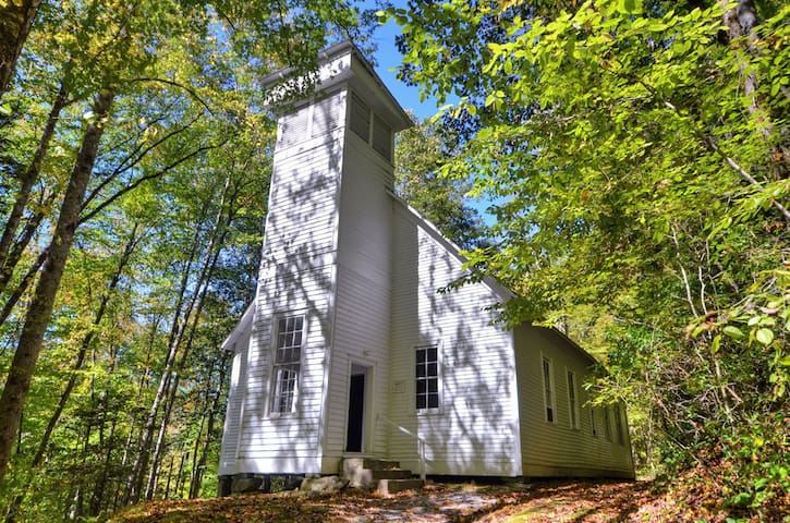
At 4.1 miles, look for the right turn into the Smokemont area. Trails in the area will wind through very scenic terrain. If you’re pressed for time, park in the parking lot straight ahead from the right turn and tour the Smokemont Church. Spring and fall are great times to get photos of pretty foliage around the church and steeple.
Smokemont Loop Trail
At 4.1 miles, look for the right turn into the Smokemont area. Trails in the area will wind through very scenic terrain. If you’re pressed for time, park in the parking lot straight ahead from the right turn and tour the Smokemont Church. Spring and fall are great times to get photos of pretty foliage around the church and steeple.
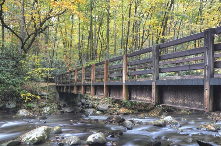
At 7.9 miles, look for parallel parking on both sides of the road. This is the parking area for the Kephart Prong Trail, which starts out as a bridge over the Oconaluftee River. Standing at the foot of the bridge creates a great photo especially in the fall. You can also capture scenes on the bridge looking to the right; you’ll get a long view of the river with overhanging trees. Or climb down the embankment on the left side and photograph the bridge going over the river.
US 441/Newfound Gap Road continues to climb to the higher elevations of the Park, where long range views of mountain ridges are plentiful. Most of these overlooks and parking areas will be on the left side.
The first long-range overlook after Kephart Prong trailhead is at 12.7 miles and is not the most ideal for photo opportunities. However if this is your first visit to the Park, it is tempting to turn in for your initial glimpse of the majestic mountains.
Kephart Prong Trail
Kephart Prong TrailAt 7.9 miles, look for parallel parking on both sides of the road. This is the parking area for the Kephart Prong Trail, which starts out as a bridge over the Oconaluftee River. Standing at the foot of the bridge creates a great photo especially in the fall. You can also capture scenes on the bridge looking to the right; you’ll get a long view of the river with overhanging trees. Or climb down the embankment on the left side and photograph the bridge going over the river.
US 441/Newfound Gap Road continues to climb to the higher elevations of the Park, where long range views of mountain ridges are plentiful. Most of these overlooks and parking areas will be on the left side.
The first long-range overlook after Kephart Prong trailhead is at 12.7 miles and is not the most ideal for photo opportunities. However if this is your first visit to the Park, it is tempting to turn in for your initial glimpse of the majestic mountains.
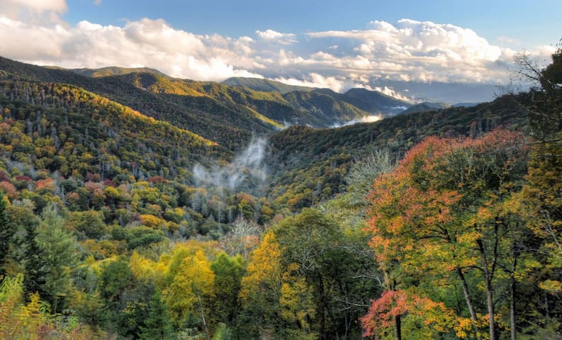
Long range views are much better from the next overlook, at 13.4 miles. This is called Webb Overlook. At the left of the parking area, there are beautiful views of mountain ridges with 2-3 distinct trees for your foreground. Or zoom in past the trees for a closer look.
Newfound Gap
Long range views are much better from the next overlook, at 13.4 miles. This is called Webb Overlook. At the left of the parking area, there are beautiful views of mountain ridges with 2-3 distinct trees for your foreground. Or zoom in past the trees for a closer look.
The next two overlooks are at 14.0 and 14.2. The first overlook only has space for a few cars with parallel parking. Look for the walkway to the right that follows alongside the road and walk out to the end. This is one of the most photogenic spots in the Park for long range views. The next overlook is just a short distance away and has more parking. Here the walkway skirts the road at the left end of the parking lot. The view is much the same as the one before it, and it is equally beautiful with a slightly different angle.
At 14.7 miles, this overlook has long range views that are gorgeous year-round. This is also the trailhead for the high elevation portion of the Deep Creek Trail. There are just a few parking spots, and a good photo may be more difficult to capture here as many cars are trying to opt for a parking space in a tight area. But it is still worth the stop; with the long range views looking out to the left.
At 15.6 miles, you will arrive at the best spot for sunrise photos – Oconaluftee Valley Overlook. When you approach this overlook, the parking lot is on the left, however the view will be to your right. There is plenty of parking here, but photographers will arrive long before sunrise to get prime spots for sunrise photography.
22 명의 현지인이 추천하는 곳
Deep Creek Trail
Deep Creek TrailThe next two overlooks are at 14.0 and 14.2. The first overlook only has space for a few cars with parallel parking. Look for the walkway to the right that follows alongside the road and walk out to the end. This is one of the most photogenic spots in the Park for long range views. The next overlook is just a short distance away and has more parking. Here the walkway skirts the road at the left end of the parking lot. The view is much the same as the one before it, and it is equally beautiful with a slightly different angle.
At 14.7 miles, this overlook has long range views that are gorgeous year-round. This is also the trailhead for the high elevation portion of the Deep Creek Trail. There are just a few parking spots, and a good photo may be more difficult to capture here as many cars are trying to opt for a parking space in a tight area. But it is still worth the stop; with the long range views looking out to the left.
At 15.6 miles, you will arrive at the best spot for sunrise photos – Oconaluftee Valley Overlook. When you approach this overlook, the parking lot is on the left, however the view will be to your right. There is plenty of parking here, but photographers will arrive long before sunrise to get prime spots for sunrise photography.
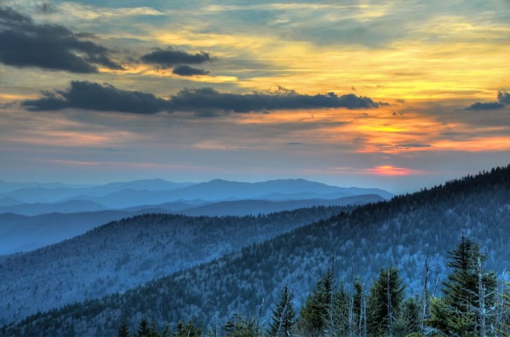
t 16.2 miles is the left turn onto Clingmans Dome Road. Follow the 7-mile-long road to the large parking area at the end. This is a great location for sunset photography, 2nd only to Morton Overlook (see below). You don’t have to climb to the observation tower to get your best sunset photo; you’ll capture fabulous photography from the parking lot. However the best vantage point will be at the farthest end of the parking lot. Some people like this area for sunrise photography, however we prefer the Oconaluftee Valley Overlook for this purpose
At 16.3 miles – assuming you didn’t make the left turn at Clingmans Dome, make the right turn into the Newfound Gap parking area. This is usually crowded, especially during peak tourist season. This is where the NC/TN state line is clearly marked, where the Appalachian Trail crosses, and is the site of the September 1940 formal dedication of the Park by President Franklin Roosevelt who spoke from the Rockefeller Memorial. There are also public restrooms here. Photo opportunities here are limited, however for long range views, step to the far right side of the parking lot, and you can view south along the ridges that define US 441, Newfound Gap Road.
319 명의 현지인이 추천하는 곳
클랭맨스돔
t 16.2 miles is the left turn onto Clingmans Dome Road. Follow the 7-mile-long road to the large parking area at the end. This is a great location for sunset photography, 2nd only to Morton Overlook (see below). You don’t have to climb to the observation tower to get your best sunset photo; you’ll capture fabulous photography from the parking lot. However the best vantage point will be at the farthest end of the parking lot. Some people like this area for sunrise photography, however we prefer the Oconaluftee Valley Overlook for this purpose
At 16.3 miles – assuming you didn’t make the left turn at Clingmans Dome, make the right turn into the Newfound Gap parking area. This is usually crowded, especially during peak tourist season. This is where the NC/TN state line is clearly marked, where the Appalachian Trail crosses, and is the site of the September 1940 formal dedication of the Park by President Franklin Roosevelt who spoke from the Rockefeller Memorial. There are also public restrooms here. Photo opportunities here are limited, however for long range views, step to the far right side of the parking lot, and you can view south along the ridges that define US 441, Newfound Gap Road.
At 17.1 miles Morton Overlook is the best place in the Park to view the sunset. At certain times of year, the sun will align itself between the peaks as it goes down, including the month of May. Plan to arrive here at least one hour ahead of time, especially on weekends or during the peak tourist seasons. Parking spots and prime viewing locations fill up quickly.
If you continue north on Newfound Gap Road (US 441), you’ll find the trailheads for Alum Cave and Chimney Tops, as well as other low elevation overlooks as you approach the Gatlinburg TN area. Turn left on Little River Road to reach the Elkmont, Tremont, and Cades Cove areas. Or turn right in Gatlinburg and look for the Roaring Fork Nature Trail (also part of the Park) for streams and historic structure photography.
56 명의 현지인이 추천하는 곳
Alum Cave Trail
Alum Cave TrailAt 17.1 miles Morton Overlook is the best place in the Park to view the sunset. At certain times of year, the sun will align itself between the peaks as it goes down, including the month of May. Plan to arrive here at least one hour ahead of time, especially on weekends or during the peak tourist seasons. Parking spots and prime viewing locations fill up quickly.
If you continue north on Newfound Gap Road (US 441), you’ll find the trailheads for Alum Cave and Chimney Tops, as well as other low elevation overlooks as you approach the Gatlinburg TN area. Turn left on Little River Road to reach the Elkmont, Tremont, and Cades Cove areas. Or turn right in Gatlinburg and look for the Roaring Fork Nature Trail (also part of the Park) for streams and historic structure photography.
If you don't have time or inclination to go on a road trip to get some magnificent shots, you can always enjoy the sunrise and sunsets from the property decks and windows. Enjoy!
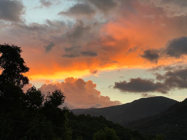
447 Lewis Ln
447 Lewis LaneIf you don't have time or inclination to go on a road trip to get some magnificent shots, you can always enjoy the sunrise and sunsets from the property decks and windows. Enjoy!
Food scene
A very popular lunch and dinner venue. Food is authentic as the owner/chefs are from Italy. Great pizza's !
87 명의 현지인이 추천하는 곳
Frankie's Italian Trattoria
1037 Soco RdA very popular lunch and dinner venue. Food is authentic as the owner/chefs are from Italy. Great pizza's !
Another local favorite. Great atmosphere for a nice dinner. The prime rib is perfectly done. The menu includes various local and regional dishes.
26 명의 현지인이 추천하는 곳
J. Arthur's
2843 Soco RdAnother local favorite. Great atmosphere for a nice dinner. The prime rib is perfectly done. The menu includes various local and regional dishes.
Great Mexican food and large selection of beer and wines. Only 7 miles from the property .
34 명의 현지인이 추천하는 곳
Papas & Beer
1863 S Main StGreat Mexican food and large selection of beer and wines. Only 7 miles from the property .
Great pancakes and homemade breakfast dishes. It is about 1.5 miles from the house.Go early on weekends to avoid long waits.
83 명의 현지인이 추천하는 곳
Joey's Pancake House
4309 Soco RdGreat pancakes and homemade breakfast dishes. It is about 1.5 miles from the house.Go early on weekends to avoid long waits.
This is a local good old fashioned southern cooking dinner. Only half a mile from the house. Less than 1/4 mile from the corner of Lewis Lane and Socco Rd.
15 명의 현지인이 추천하는 곳
Country Vittles Family Style Restaurant
3589 Soco RdThis is a local good old fashioned southern cooking dinner. Only half a mile from the house. Less than 1/4 mile from the corner of Lewis Lane and Socco Rd.
It is a must for NC BBQ lovers. It is located at about 8 miles from the house.
191 명의 현지인이 추천하는 곳
Haywood Smokehouse
79 Elysinia AveIt is a must for NC BBQ lovers. It is located at about 8 miles from the house.
This small restaurant is the perfect place for a romantic dinner in Waynesville . Pricey but well with it. It has a gourmet set menu and patrons must make reservations at least two days ahead.
49 명의 현지인이 추천하는 곳
Chef's Table
30 Church StThis small restaurant is the perfect place for a romantic dinner in Waynesville . Pricey but well with it. It has a gourmet set menu and patrons must make reservations at least two days ahead.
A perfect family restaurant in the heart of Waynesville town center. The menu includes a varied assemble of Southern Food and American favorites. Good atmosphere and plan ahead as it gets quite crowded. During COVID they have outdoor dinning.
158 명의 현지인이 추천하는 곳
Sweet Onion
39 Miller StA perfect family restaurant in the heart of Waynesville town center. The menu includes a varied assemble of Southern Food and American favorites. Good atmosphere and plan ahead as it gets quite crowded. During COVID they have outdoor dinning.
Authentic Souther home cooking. Has been around since 1956. No non-sense menu, favorite are fried chicken and fresh trout. Affordable and has indoor and outdoor seating.
7 명의 현지인이 추천하는 곳
Carver's Maggie Valley Restaurant
2804 Soco RdAuthentic Souther home cooking. Has been around since 1956. No non-sense menu, favorite are fried chicken and fresh trout. Affordable and has indoor and outdoor seating.
Organic Beans Coffee
3680 Soco RdGreat coffee and pastries.
여행 팁
놓치면 후회하는 장소/활동
Take This Mini Road Trip to Capture Some Great Photos
Whether you’re a professional photographer or an amateur, the Great Smoky Mountains National Park is one of the most diverse and photogenic landscapes in the United States. Forests, long range mountain views, beautiful streams and serene valleys make this national treasure one of the richest experiences for landscape photography. Read along to find the best spots for sunrise and sunset photography on the North Carolina side, along with great photo opportunities along the way. Our location descriptions are described via mileage distance from the Cherokee entrance to the Park (US 441)