
Things to do near Moi
Hiking
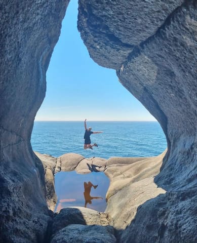
The horizontal potholes at Brufjell were created during the Ice Age some 20.000 years ago when the sea level was higher. The potholes lie horizontally 20 meters above sea level and are of various sizes and some are so big that people can climb inside them.
The Brufjell mountains are located at Åna-Sira, just outside Flekkefjord in Southern Norway. The potholes and caves at Brufjell are a popular hiking destination in Southern Norway.
These potholes were created during the Ice Age over 20,000 years ago. The high and rough seas continually crashed against the rock cliffs creating the potholes in mountains which used to be higher than Mt. Everest.
Stunning views
Once at the top of the cliffs, you can experience panoramic views over the entire coastline all the way to the Lista lighthouse. This is a perfect opportunity for pictures, so make sure you have a good camera. At the top of Brufjell you will see a mail box. Feel free to write your name and nationality.
There is a relatively steep ascend before arriving at Brufjell. Follow the sign to the potholes and walk down the mountain. It gets very steep and people who are afraid of hights might find it a bit scary. Some safe handles have been put up to facilitate the short climbing.
When you arrive at the potholes, you can sit inside them in a type of cave and enjoy the views. This is the point where many people take pictures of friends standing at the entrance to these caves.
As is the case with any hiking adventure, please inform someone where you are going and what time you will be back. Take a camera, some food and at least one litre of water. The steep areas of the hike can be a little difficult so children aged 10 and above are recommended for the journey.
Closed at Winter
All use of the public trails to the Brufjell pot holes is at your own risk during the winter closure. Flekkefjord municipality has closed the toilet for the winter season between 01.11.2019 – 01.03.2020 at Brufjell.
How to get there
Drive road 44 (the North Sea road) to Åna- Sira. Driving down the mountain towards Åna-Sira, notice the sign "Roligheten" on the left side. Drive down this small road towards the small community.
Park in the parking lot at the school and from there, walk approximately 2 kilometres along the local road towards to the trail, enjoying the little white houses dotted alongside the road and the fjord that runs parallel to the road. At the turnaround the paths toward Brufjell Mountain start.
The whole journey is marked with signs and painted stones to ensure that you go in the right direction. At a normal pace, it will take about one hour and a half to reach the potholes from the start of the hiking trail. Along the way, you will pass Sandviga beach. Its white pebbles and clear water are a welcome relief if you are hiking during summer.
For a more detailed description, and a map, please contact the tourist information in Flekkefjord.
Brufjell Potholes Flekkefjord
The horizontal potholes at Brufjell were created during the Ice Age some 20.000 years ago when the sea level was higher. The potholes lie horizontally 20 meters above sea level and are of various sizes and some are so big that people can climb inside them.
The Brufjell mountains are located at Åna-Sira, just outside Flekkefjord in Southern Norway. The potholes and caves at Brufjell are a popular hiking destination in Southern Norway.
These potholes were created during the Ice Age over 20,000 years ago. The high and rough seas continually crashed against the rock cliffs creating the potholes in mountains which used to be higher than Mt. Everest.
Stunning views
Once at the top of the cliffs, you can experience panoramic views over the entire coastline all the way to the Lista lighthouse. This is a perfect opportunity for pictures, so make sure you have a good camera. At the top of Brufjell you will see a mail box. Feel free to write your name and nationality.
There is a relatively steep ascend before arriving at Brufjell. Follow the sign to the potholes and walk down the mountain. It gets very steep and people who are afraid of hights might find it a bit scary. Some safe handles have been put up to facilitate the short climbing.
When you arrive at the potholes, you can sit inside them in a type of cave and enjoy the views. This is the point where many people take pictures of friends standing at the entrance to these caves.
As is the case with any hiking adventure, please inform someone where you are going and what time you will be back. Take a camera, some food and at least one litre of water. The steep areas of the hike can be a little difficult so children aged 10 and above are recommended for the journey.
Closed at Winter
All use of the public trails to the Brufjell pot holes is at your own risk during the winter closure. Flekkefjord municipality has closed the toilet for the winter season between 01.11.2019 – 01.03.2020 at Brufjell.
How to get there
Drive road 44 (the North Sea road) to Åna- Sira. Driving down the mountain towards Åna-Sira, notice the sign "Roligheten" on the left side. Drive down this small road towards the small community.
Park in the parking lot at the school and from there, walk approximately 2 kilometres along the local road towards to the trail, enjoying the little white houses dotted alongside the road and the fjord that runs parallel to the road. At the turnaround the paths toward Brufjell Mountain start.
The whole journey is marked with signs and painted stones to ensure that you go in the right direction. At a normal pace, it will take about one hour and a half to reach the potholes from the start of the hiking trail. Along the way, you will pass Sandviga beach. Its white pebbles and clear water are a welcome relief if you are hiking during summer.
For a more detailed description, and a map, please contact the tourist information in Flekkefjord.
Sightseeing
Sogndalstrand is one of the most popular tourist destinations in Rogaland. The village has pedestrian streets and small shops and galleries and a salmon river is floating through the village.
Sogndalstrand is one of the most popular tourist destinations in Rogaland, and the only village in Norway where both the wooden buildings from the 1700's and 1800's and the surrounding cultural landscape are listed. Business development booming It used to be a staple port and its own municipality up until 1944. In the last few years it has experienced quite a boom with the development of a culture hotel, gallery, golf course, village shop, outdoor amphi theatre (Sogndalstrand Amfi), sculpture jetty, sea rafting, a fishing museum and more. Several large concerts are held in Sogndalstrand Amfi in the summer. The Sokna, a salmon river, flows into the fjord near Sogndalstrand, and is popular for fishing.
21 명의 현지인이 추천하는 곳
Sogndalstrand
Sogndalstrand is one of the most popular tourist destinations in Rogaland. The village has pedestrian streets and small shops and galleries and a salmon river is floating through the village.
Sogndalstrand is one of the most popular tourist destinations in Rogaland, and the only village in Norway where both the wooden buildings from the 1700's and 1800's and the surrounding cultural landscape are listed. Business development booming It used to be a staple port and its own municipality up until 1944. In the last few years it has experienced quite a boom with the development of a culture hotel, gallery, golf course, village shop, outdoor amphi theatre (Sogndalstrand Amfi), sculpture jetty, sea rafting, a fishing museum and more. Several large concerts are held in Sogndalstrand Amfi in the summer. The Sokna, a salmon river, flows into the fjord near Sogndalstrand, and is popular for fishing.
Active Sightseeing
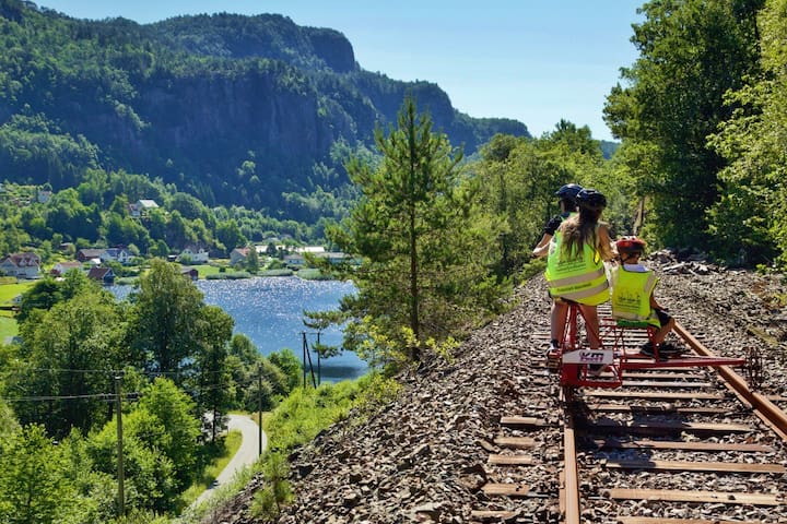
Explore the Flekkefjord railway line. Stunning nature scenes offer visitors a great day out. Suitable for the whole family, young children included. Daily tours arranged during the summer months, departing from the bus station.
This tour combines a fantastic nature experience together with a fascinating architectural insight into the making of this seventeen kilometre long Flekkefjordbanen rail track.
From the year 1904 until 1990, the Flekkefjordbanen rail track connected Flekkefjord with the south Norway rail link, Sørlandsbanen. The Flekkefjordbanen link was an important connection for the locals who frequented the train to meet with friends and to visit other towns. The last journey the Flekkefjordbanen made was on New Years Eve 1990, travelling from Flekkefjord to Sira town. A railway era was over.
The Flekkefjords’ Rail Track Friends are working towards preserving the track and turn it into a living museum, using the slogan ‘cultural salvation through active use’. The persistence and hard work has paid off and today the seventeen kilometres long rail track has been put forward for a cultural protection scheme.
Rail biking on the line has become a popular sport amongst locals, visitors and conference delegates. The activity is suitable for young and old alike. The track takes you through a beautiful and varied natural landscape and you can’t fail to be impressed by the architectural wonder of this construction taking you through no less than seventeen tunnels.
Tours every day during summer.
Outside times of scheduled tours, rail biking can be arranged directly with Flekkefjordbanen AS. Season: June 1. - September 30.
Remember to bring something to drink, snacks and a camera! Picnic tables and WC at Flikkeid. Bring a coat for the cold tunnels.
For more information or to rent a rail bike, see the website.
25 명의 현지인이 추천하는 곳
Flekkefjord Line
6 JernbaneveienExplore the Flekkefjord railway line. Stunning nature scenes offer visitors a great day out. Suitable for the whole family, young children included. Daily tours arranged during the summer months, departing from the bus station.
This tour combines a fantastic nature experience together with a fascinating architectural insight into the making of this seventeen kilometre long Flekkefjordbanen rail track.
From the year 1904 until 1990, the Flekkefjordbanen rail track connected Flekkefjord with the south Norway rail link, Sørlandsbanen. The Flekkefjordbanen link was an important connection for the locals who frequented the train to meet with friends and to visit other towns. The last journey the Flekkefjordbanen made was on New Years Eve 1990, travelling from Flekkefjord to Sira town. A railway era was over.
The Flekkefjords’ Rail Track Friends are working towards preserving the track and turn it into a living museum, using the slogan ‘cultural salvation through active use’. The persistence and hard work has paid off and today the seventeen kilometres long rail track has been put forward for a cultural protection scheme.
Rail biking on the line has become a popular sport amongst locals, visitors and conference delegates. The activity is suitable for young and old alike. The track takes you through a beautiful and varied natural landscape and you can’t fail to be impressed by the architectural wonder of this construction taking you through no less than seventeen tunnels.
Tours every day during summer.
Outside times of scheduled tours, rail biking can be arranged directly with Flekkefjordbanen AS. Season: June 1. - September 30.
Remember to bring something to drink, snacks and a camera! Picnic tables and WC at Flikkeid. Bring a coat for the cold tunnels.
For more information or to rent a rail bike, see the website.