
Stuart and Debbie's Guidebook
Food scene
Glenapp Castle
Fantastic location with Afternoon Teas to die for!
Well stocked Garden Centre including fantastic Tea Rooms and Coffee Shop, Trae Bakes.
Craigiemains Home & Garden Centre
Main StreetWell stocked Garden Centre including fantastic Tea Rooms and Coffee Shop, Trae Bakes.
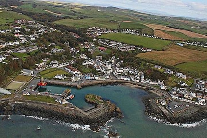
The Kings Arms has for more than 2 centuries been at the centre of Ballantrae village life. It was recently acquired for the community to become a village hub and pub for both locals and visitors to the area alike.
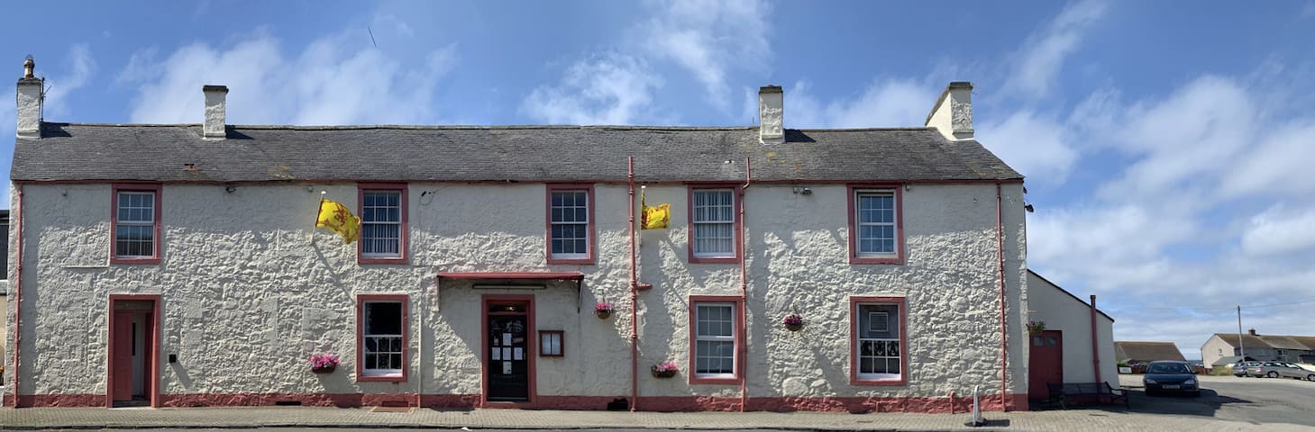
Kings Arms Hotel
40 Main StThe Kings Arms has for more than 2 centuries been at the centre of Ballantrae village life. It was recently acquired for the community to become a village hub and pub for both locals and visitors to the area alike.
Bladnoch’s rich history dates back to 1817, when John and Thomas McClelland were first granted a licence to distil Whisky on their Bladnoch farm in Scotland’s Lowlands.
For nearly a century, successive generations of McClelland family grew and modernised the distillery. At its peak, the site had six washbacks and annual production of approximately 230,000 litres of alcohol, which cemented its status as the “Queen of the Lowlands”
17 명의 현지인이 추천하는 곳
Bladnoch Distillery
Bladnoch’s rich history dates back to 1817, when John and Thomas McClelland were first granted a licence to distil Whisky on their Bladnoch farm in Scotland’s Lowlands.
For nearly a century, successive generations of McClelland family grew and modernised the distillery. At its peak, the site had six washbacks and annual production of approximately 230,000 litres of alcohol, which cemented its status as the “Queen of the Lowlands”
A wonderful Inn sitting beside the beautiful Luce Bay. Enjoy a truly wonderful view by sitting in our conservatory or in our beer garden. You may be lucky enough to see the dolphins swim by or watch the cormorants dive.
Cock Inn
2 A747A wonderful Inn sitting beside the beautiful Luce Bay. Enjoy a truly wonderful view by sitting in our conservatory or in our beer garden. You may be lucky enough to see the dolphins swim by or watch the cormorants dive.
Golf Courses
Girvan Golf Course
40 Golf Course RdGreat semi links course in fantastic surroundings.
The Trump Turnberry is a golf resort on the coast of the outer Firth of Clyde in southwestern Scotland owned by Donald Trump. Located in South Ayrshire on the rugged coast, it comprises three links golf courses, a golf academy, a five-star James Miller-designed hotel from 1906, along with lodge and cottage accommodations. The prominent rock island Ailsa Craig is readily visible to the southwest.
13 명의 현지인이 추천하는 곳
Turnberry Golf Club
Maidens RoadThe Trump Turnberry is a golf resort on the coast of the outer Firth of Clyde in southwestern Scotland owned by Donald Trump. Located in South Ayrshire on the rugged coast, it comprises three links golf courses, a golf academy, a five-star James Miller-designed hotel from 1906, along with lodge and cottage accommodations. The prominent rock island Ailsa Craig is readily visible to the southwest.
The 'County' is one of the most popular holiday golf courses in South West Scotland, an 18-hole, true links course situated on the shores of Luce Bay. The excellent condition of the course, combined with subtlely sloping greens and changing sea breezes, provide a test of golf for both high and low handicappers. The area enjoys a temperate climate, so golfing is possible year round, and the club is renowned for its friendly welcome to visitors.
Wigtownshire County Golf Course
The 'County' is one of the most popular holiday golf courses in South West Scotland, an 18-hole, true links course situated on the shores of Luce Bay. The excellent condition of the course, combined with subtlely sloping greens and changing sea breezes, provide a test of golf for both high and low handicappers. The area enjoys a temperate climate, so golfing is possible year round, and the club is renowned for its friendly welcome to visitors.
City/town information
Castle Douglas is designated Food Town in the heart of Dumfries and Galloway. This 18th-century market town is a prime location for speciality shopping, having around 50 local businesses that sell and produce food and drink and a variety of art, clothing, and goods stores.
34 명의 현지인이 추천하는 곳
Castle Douglas
Castle Douglas is designated Food Town in the heart of Dumfries and Galloway. This 18th-century market town is a prime location for speciality shopping, having around 50 local businesses that sell and produce food and drink and a variety of art, clothing, and goods stores.
Sightseeing
Ailsa Craig, granite islet, South Ayrshire council area, Scotland, at the mouth of the Firth of Clyde and 10 miles (16 km) off the coast of South Ayrshire, to which it belongs. It is nicknamed “Paddy’s Milestone” for its location halfway between Glasgow and Belfast (Northern Ireland). The name Ailsa Craig is thought to derive from Gaelic words meaning “Fairy Rock.” About 0.75 mile (1.2 km) long and 0.5 mile (0.8 km) wide, Ailsa Craig rises steeply to an elevation of 1,114 feet (340 metres) and is accessible only on the eastern side. Its rock has been used to make curling stones (used in the Celtic sport, and hence known as “Ailsas”) as well as paving stones. Some scanty grass supports goats and rabbits. The precipices have large breeding colonies of gannets and other seabirds.
12 명의 현지인이 추천하는 곳
Ailsa Craig
Ailsa Craig, granite islet, South Ayrshire council area, Scotland, at the mouth of the Firth of Clyde and 10 miles (16 km) off the coast of South Ayrshire, to which it belongs. It is nicknamed “Paddy’s Milestone” for its location halfway between Glasgow and Belfast (Northern Ireland). The name Ailsa Craig is thought to derive from Gaelic words meaning “Fairy Rock.” About 0.75 mile (1.2 km) long and 0.5 mile (0.8 km) wide, Ailsa Craig rises steeply to an elevation of 1,114 feet (340 metres) and is accessible only on the eastern side. Its rock has been used to make curling stones (used in the Celtic sport, and hence known as “Ailsas”) as well as paving stones. Some scanty grass supports goats and rabbits. The precipices have large breeding colonies of gannets and other seabirds.
The dome of Knockdolian rises like a collapsing steamed pudding above the gentle braes of South Ayrshire. It’s the less celebrated, less dramatic twin of Ailsa Craig (the volcanic plug pointing the way to Ireland in the sea to the northwest), but let that take nothing away from the enjoyable ascent. Short grass – particularly early in the year – and a road around the foot make the ascent of this 265-metre hill swift and fairly straightforward, with superb views up the River Stinchar, and of course out to Paddy’s Milestone herself. On the drive to the start, watch out for wandering pheasants which haven’t consulted the Green Cross Code.
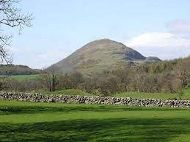
Knockdolian
The dome of Knockdolian rises like a collapsing steamed pudding above the gentle braes of South Ayrshire. It’s the less celebrated, less dramatic twin of Ailsa Craig (the volcanic plug pointing the way to Ireland in the sea to the northwest), but let that take nothing away from the enjoyable ascent. Short grass – particularly early in the year – and a road around the foot make the ascent of this 265-metre hill swift and fairly straightforward, with superb views up the River Stinchar, and of course out to Paddy’s Milestone herself. On the drive to the start, watch out for wandering pheasants which haven’t consulted the Green Cross Code.
Dating back some 700 years and built adjacent to the ruins of nearby Dunskey Castle, Portpatrick's position on the Rhins of Galloway affords visitors views of the Northern Irish coast 21 miles (34 km) to the west, with cliff-top walks and beaches both north and south. The Gulf Stream, flowing in from the north, gives the coastline a pleasant climate, in which subtropical plant life can flourish.
Portpatrick has a Community Council,[5] and an annual Life Boat Week, featuring parades, activities, and a firework display.[6] There are bowls clubs, a golf club, many guesthouses and hotels, and rustic public houses. The village is also home to a mini putting course.
By the inner harbour is the starting point of the Southern Upland Way, a long-distance walking route to Cockburnspath on the east coast. The Portpatrick Hotel, built in 1905 and extended in 1907, sits on the cliffs above this point.
24 명의 현지인이 추천하는 곳
Portpatrick
Dating back some 700 years and built adjacent to the ruins of nearby Dunskey Castle, Portpatrick's position on the Rhins of Galloway affords visitors views of the Northern Irish coast 21 miles (34 km) to the west, with cliff-top walks and beaches both north and south. The Gulf Stream, flowing in from the north, gives the coastline a pleasant climate, in which subtropical plant life can flourish.
Portpatrick has a Community Council,[5] and an annual Life Boat Week, featuring parades, activities, and a firework display.[6] There are bowls clubs, a golf club, many guesthouses and hotels, and rustic public houses. The village is also home to a mini putting course.
By the inner harbour is the starting point of the Southern Upland Way, a long-distance walking route to Cockburnspath on the east coast. The Portpatrick Hotel, built in 1905 and extended in 1907, sits on the cliffs above this point.
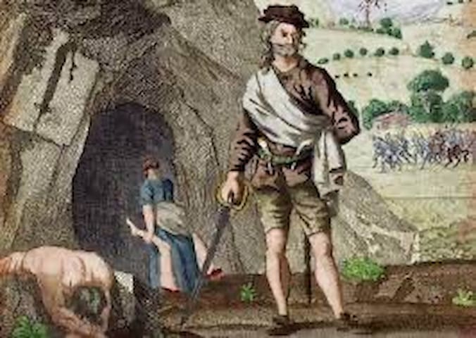
Little is known for certain about his early life, however Sawney Bean is believed to have been born in East Lothian in the late 15th century, and was a tanner by trade. The latter part of his life is a little better documented following his relocation across country to Ayrshire and his marriage.
The newly wed Mr and Mrs Sawney Bean set up home at Bennane Cave, by Ballantrae in Ayrshire, Scotland.
Bennane Cave was rather an imposing abode, with tunnels penetrating the solid rock and extending for more than a mile in length. In addition, the accommodation featured lots of side passages where a young couple could extend into, and convert over the next 25 years, to accommodate a growing family.
The cave’s entrance was flooded for several hundred metres, twice a day at high tide, a nice draught exclusion feature!
Sawney Bean's Cave
Little is known for certain about his early life, however Sawney Bean is believed to have been born in East Lothian in the late 15th century, and was a tanner by trade. The latter part of his life is a little better documented following his relocation across country to Ayrshire and his marriage.
The newly wed Mr and Mrs Sawney Bean set up home at Bennane Cave, by Ballantrae in Ayrshire, Scotland.
Bennane Cave was rather an imposing abode, with tunnels penetrating the solid rock and extending for more than a mile in length. In addition, the accommodation featured lots of side passages where a young couple could extend into, and convert over the next 25 years, to accommodate a growing family.
The cave’s entrance was flooded for several hundred metres, twice a day at high tide, a nice draught exclusion feature!
Walking and Cycling
The visitor centre overlooks tranquil Clatteringshaws Loch, a haven for waterbirds in summer, and beyond to the rolling Galloway Hills.
https://forestryandland.gov.scot/visit/forest-parks/galloway-forest-park/clatteringshaws-visitor-centre
On a clear day, look out for the mighty Merrick, highest hill in the Southern Uplands. Soak up the stunning views or meander beside the loch to the historic Bruce's Stone, one of two stones dedicated to the Scottish king in the Forest Park.
This is also one of the best places to enjoy the night sky – the visitor centre overlooks the darkest part of the Forest Park, which ensures a particularly dramatic stellar show.
Clatteringshaws
The visitor centre overlooks tranquil Clatteringshaws Loch, a haven for waterbirds in summer, and beyond to the rolling Galloway Hills.
https://forestryandland.gov.scot/visit/forest-parks/galloway-forest-park/clatteringshaws-visitor-centre
On a clear day, look out for the mighty Merrick, highest hill in the Southern Uplands. Soak up the stunning views or meander beside the loch to the historic Bruce's Stone, one of two stones dedicated to the Scottish king in the Forest Park.
This is also one of the best places to enjoy the night sky – the visitor centre overlooks the darkest part of the Forest Park, which ensures a particularly dramatic stellar show.
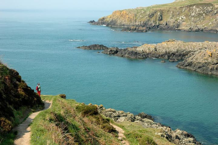
The Ayrshire Coastal Path (ACP) from Glenapp to Skelmorlie runs 100 miles along one of the finest panoramic coastlines in the British Isles. Crowned with a superb backdrop of the ever-changing profile of the mountains of Arran across the Firth of Clyde, this coastline is steeped in history and teeming with wildlife.
Ayrshire Coastal Path Trail Head
Unnamed RoadThe Ayrshire Coastal Path (ACP) from Glenapp to Skelmorlie runs 100 miles along one of the finest panoramic coastlines in the British Isles. Crowned with a superb backdrop of the ever-changing profile of the mountains of Arran across the Firth of Clyde, this coastline is steeped in history and teeming with wildlife.
Running across 214 miles of superb and varied country the Southern Upland Way is still undiscovered by many. It starts from Portpatrick on the south west coast and finishes at Cockburnspath on the east. There are no summits above 3000ft, but over 80 rise above 2000ft.
The Way provides a real challenge for the experienced. On the other hand, some sections are ideal for families and the less ambitious. Experienced walkers consider the route to be one of the most challenging of Scotland’s Great Trails.
Travelling the entire 214 miles of the Southern Upland Way will take you through an amazing variety of scenery. This will provide a challenge that will give you a fantastic sense of achievement upon completion. Many of the longer sections are very arduous and would be difficult for some to manage in a single day. To avoid this some accommodation providers will collect you from pick up points along the route and drop you off again the next morning. A transfer service is also available to move your luggage to your next night’s accommodation. You can download a series of leaflets to help explain the surrounding landscape, wildlife and local history.
Most people take about 12 to 16 days to complete the route in one go. It can also be split into two or more trips. You can do Portpatrick to Moffat in 6 to 8 days and Moffat to Cockburnspath in 6 to 8 days. Or take it at your own pace whether fast or slow and enjoy the experience. Don't forget to claim a completion certificate when you have finished.
Southern Upland Way
Southern Upland WayRunning across 214 miles of superb and varied country the Southern Upland Way is still undiscovered by many. It starts from Portpatrick on the south west coast and finishes at Cockburnspath on the east. There are no summits above 3000ft, but over 80 rise above 2000ft.
The Way provides a real challenge for the experienced. On the other hand, some sections are ideal for families and the less ambitious. Experienced walkers consider the route to be one of the most challenging of Scotland’s Great Trails.
Travelling the entire 214 miles of the Southern Upland Way will take you through an amazing variety of scenery. This will provide a challenge that will give you a fantastic sense of achievement upon completion. Many of the longer sections are very arduous and would be difficult for some to manage in a single day. To avoid this some accommodation providers will collect you from pick up points along the route and drop you off again the next morning. A transfer service is also available to move your luggage to your next night’s accommodation. You can download a series of leaflets to help explain the surrounding landscape, wildlife and local history.
Most people take about 12 to 16 days to complete the route in one go. It can also be split into two or more trips. You can do Portpatrick to Moffat in 6 to 8 days and Moffat to Cockburnspath in 6 to 8 days. Or take it at your own pace whether fast or slow and enjoy the experience. Don't forget to claim a completion certificate when you have finished.
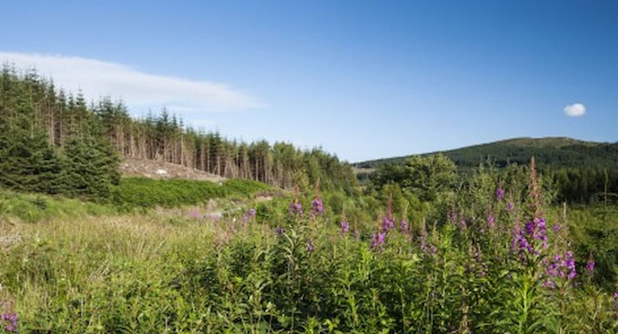
The 7stanes are world-class mountain biking centres that span the south of Scotland. Their award-winning trails offer some of the best off road routes in the country and attract riders from across the UK and beyond.
Although the routes are promoted as Mountain Bike Trails, they are particularly suited to Cyclocross or Gravel bikes.
You don’t have to be an experienced off road cyclist to enjoy these famous trails: there are a wide range of routes to suit beginners, families and experts. Plus, many of the centres also have skills areas for you to practise your technique.
6 명의 현지인이 추천하는 곳
7Stanes: Glentrool Mountain Bike Trails
The 7stanes are world-class mountain biking centres that span the south of Scotland. Their award-winning trails offer some of the best off road routes in the country and attract riders from across the UK and beyond.
Although the routes are promoted as Mountain Bike Trails, they are particularly suited to Cyclocross or Gravel bikes.
You don’t have to be an experienced off road cyclist to enjoy these famous trails: there are a wide range of routes to suit beginners, families and experts. Plus, many of the centres also have skills areas for you to practise your technique.
Beaches
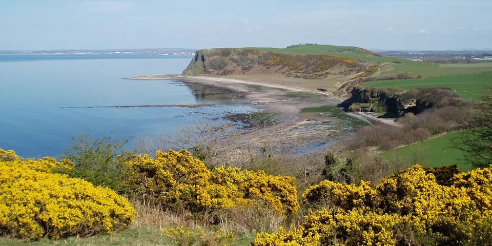
Girvan is one of Ayrshire’s most popular beaches, and the town offers a variety of traditional seaside activities. The beach is mostly sandy, although heading southwards down the coast, away from the harbour, it turns to a mixture of pebbles at the top of the beach and sand closer to the water.
Immediately opposite the beach the spectacular granite rockface of Ailsa Craig, now a bird reserve, looms out of the water. There are also excellent views out over the Firth of Clyde, as far as the Isle of Arran and beyond that, the Mull of Kintyre Peninsula is sometimes visible on a clear day. From the beach there are also good views of the mountains to the south of Girvan. Seals can occasionally be spotted bobbing up and down in the waters close to the harbour.
At the northern end of the beach, where the pretty working harbour is found, there is a small boating lake. From here, a bench-lined promenade runs southwards alongside the beach, which is backed by plenty of green spaces, including stair park. There are plenty of suitable spots for a picnic.
Roadside parking is available alongside much of the beach, which can be accessed via stairs or a slipway. Facilities such as toilets and cafes can be found at the northern end in the Quay Zone, which also contains a swimming pool, gym, and children’s play area. There are quite a few shops and places to eat in the town centre of Girvan, not far from the harbour.
7 명의 현지인이 추천하는 곳
거반 비치
Girvan is one of Ayrshire’s most popular beaches, and the town offers a variety of traditional seaside activities. The beach is mostly sandy, although heading southwards down the coast, away from the harbour, it turns to a mixture of pebbles at the top of the beach and sand closer to the water.
Immediately opposite the beach the spectacular granite rockface of Ailsa Craig, now a bird reserve, looms out of the water. There are also excellent views out over the Firth of Clyde, as far as the Isle of Arran and beyond that, the Mull of Kintyre Peninsula is sometimes visible on a clear day. From the beach there are also good views of the mountains to the south of Girvan. Seals can occasionally be spotted bobbing up and down in the waters close to the harbour.
At the northern end of the beach, where the pretty working harbour is found, there is a small boating lake. From here, a bench-lined promenade runs southwards alongside the beach, which is backed by plenty of green spaces, including stair park. There are plenty of suitable spots for a picnic.
Roadside parking is available alongside much of the beach, which can be accessed via stairs or a slipway. Facilities such as toilets and cafes can be found at the northern end in the Quay Zone, which also contains a swimming pool, gym, and children’s play area. There are quite a few shops and places to eat in the town centre of Girvan, not far from the harbour.
Castles
Dunure Castle is located on the west coast of Scotland, in South Ayrshire, about five miles south of Ayr and close to the village of Dunure. Today the castle stands in ruins on a rocky promontory on the Carrick coast, overlooking the small harbour of Dunure.
13 명의 현지인이 추천하는 곳
던유어 성
19 Castle RdDunure Castle is located on the west coast of Scotland, in South Ayrshire, about five miles south of Ayr and close to the village of Dunure. Today the castle stands in ruins on a rocky promontory on the Carrick coast, overlooking the small harbour of Dunure.
Robert Adam’s cliff-top masterpiece rises above a world of woods, beaches, secret follies and play parks
Discover 40 buildings and secret follies in this country park, including the magnificent cliff-top castle.
Don’t miss Robert Adam’s Oval Staircase – the dramatic centrepiece of the castle.
Explore the woods, beaches, parkland, Swan Pond, deer park and cliffs.
Admire the enormous collection of flintlock pistols and military swords.
Run wild in the Adventure Cove and Wild Woodland play areas.
This glorious 260ha estate was once the playground of David Kennedy, 10th Earl of Cassillis – a man who was keen to impress with his wealth and status. Opulent to the extreme, the park is planted with conifers and beech, sculpted around miles of sandy coastline dotted with caves, and finished off with a Swan Pond, an ice house, flamboyant formal gardens and fruit-filled glasshouses.
The castle itself is perched on the Ayrshire cliffs, incorporating everything the earl could wish for in his country home. It was designed by Robert Adam in the late 18th century and is filled to the turrets with treasures that tell the stories of the people who lived here.
106 명의 현지인이 추천하는 곳
컬지안 성
Robert Adam’s cliff-top masterpiece rises above a world of woods, beaches, secret follies and play parks
Discover 40 buildings and secret follies in this country park, including the magnificent cliff-top castle.
Don’t miss Robert Adam’s Oval Staircase – the dramatic centrepiece of the castle.
Explore the woods, beaches, parkland, Swan Pond, deer park and cliffs.
Admire the enormous collection of flintlock pistols and military swords.
Run wild in the Adventure Cove and Wild Woodland play areas.
This glorious 260ha estate was once the playground of David Kennedy, 10th Earl of Cassillis – a man who was keen to impress with his wealth and status. Opulent to the extreme, the park is planted with conifers and beech, sculpted around miles of sandy coastline dotted with caves, and finished off with a Swan Pond, an ice house, flamboyant formal gardens and fruit-filled glasshouses.
The castle itself is perched on the Ayrshire cliffs, incorporating everything the earl could wish for in his country home. It was designed by Robert Adam in the late 18th century and is filled to the turrets with treasures that tell the stories of the people who lived here.
Ardstinchar Castle is said to have been built by Hugh Kennedy in the middle of the 15th century. Now reduced to a fragment of the keep and a few wall foundations, it originally occupied an irregular platform circa 120' square. The gate was apparently at the NW angle, and the keep occupied the highest point at the eastern angle. About 1770 the castle was used as a quarry for material for a bridge over the R Stinchar.
The remains of Ardstinchar Castle, occupying the summit of a rock outcrop, consist of an irregularly shaped, four-sided court-yard with the main tower on the east and a second tower in the middle of the west wall. The main tower measures 8.7m by 6m over walls 1.1m thick and stands to a height of 15m. The remains of the other tower are too slight for measurement. The court-yard wall varies from 1m to 1.6m wide and there are traces of subsidiary buildings abutting its inner face.
The entrance to the court-yard was apparently in the north angle where socket holes are visible in the wall. A rock-cut ditch 8m wide and 1.5m deep lies outside the NE court-yard wall, and on the west there is a shallow ditch, 7m wide by 0.6m deep, with a broad rampart about 3m high on its counterscarp.
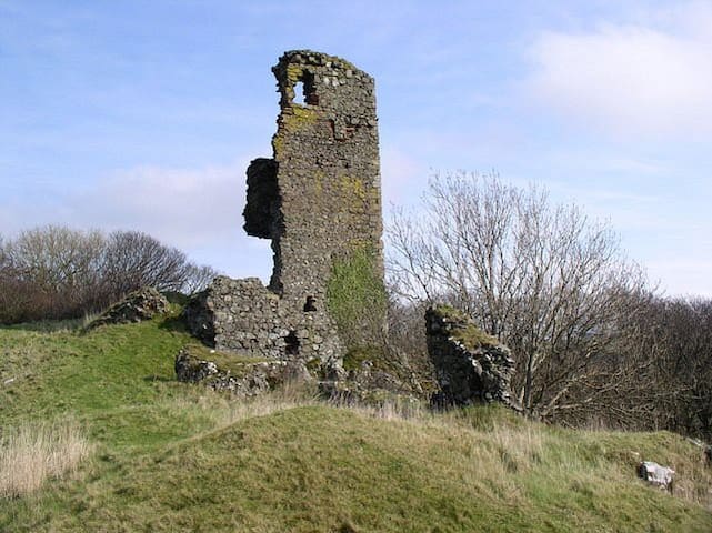
Ardstinchar Castle
1 Mains RoadArdstinchar Castle is said to have been built by Hugh Kennedy in the middle of the 15th century. Now reduced to a fragment of the keep and a few wall foundations, it originally occupied an irregular platform circa 120' square. The gate was apparently at the NW angle, and the keep occupied the highest point at the eastern angle. About 1770 the castle was used as a quarry for material for a bridge over the R Stinchar.
The remains of Ardstinchar Castle, occupying the summit of a rock outcrop, consist of an irregularly shaped, four-sided court-yard with the main tower on the east and a second tower in the middle of the west wall. The main tower measures 8.7m by 6m over walls 1.1m thick and stands to a height of 15m. The remains of the other tower are too slight for measurement. The court-yard wall varies from 1m to 1.6m wide and there are traces of subsidiary buildings abutting its inner face.
The entrance to the court-yard was apparently in the north angle where socket holes are visible in the wall. A rock-cut ditch 8m wide and 1.5m deep lies outside the NE court-yard wall, and on the west there is a shallow ditch, 7m wide by 0.6m deep, with a broad rampart about 3m high on its counterscarp.